SVAMITVA Scheme
SVAMITVA Scheme is a Central Sector scheme launched by Hon’ble Prime Minister of India on National Panchayat Day i.e 24th April 2020. The Ministry of Panchayati Raj (MoPR) is the Nodal Ministry for implementation of the scheme. In the States, the Revenue Department / Land Records Department will be the Nodal Department and shall carry out the scheme with support of State Panchayati Raj Department. Survey of India shall work as the technology partner for implementation.
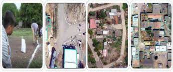
The scheme aims to provide an integrated property validation solution for rural India. The demarcation of rural abadi areas would be done using Drone Surveying technology. This would provide the ‘record of rights’ to village household owners possessing houses in inhabited rural areas in villages which, in turn, would enable them to use their property as a financial asset for taking loans and other financial benefits from Bank
The scheme seeks to achieve the following objectives: –
-
- To bring financial stability to the citizens in rural India by enabling them to use their property as a financial asset for taking loans and other financial benefits.
- Creation of accurate land records for rural planning.
- Determination of property tax, which would accrue to the GPs directly in States where it is devolved or else, add to the State exchequer.
- Creation of survey infrastructure and GIS maps that can be leveraged by any department for their use.
- To support in preparation of better-quality Gram Panchayat Development Plan (GPDP) by making use of GIS maps.
- To reduce property related disputes and legal cases
Key Points
- SVAMITVA (Survey of Villages and Mapping with Improvised Technology in Village Areas)scheme is a collaborative effort of the Ministry of Panchayati Raj, State Panchayati Raj Departments, State Revenue Departments and Survey of India.
- Aim:
- To provide an integrated property validation solution for rural India.
- It is a scheme for mappingthe land parcels in rural inhabited areas using drone technology and Continuously Operating Reference Station (CORS).
- The mapping will be done across the country in a phase-wise manner over a period of four years – from 2020 to 2024.
Benefits
- The scheme will help in streamlining planning and revenue collectionin rural areas and ensuring clarity on property rights.
- The scheme will enable creation of better-quality Gram Panchayat Development Plans (GPDPs),using the maps created under this programme.
- The Gram Panchayats are constitutionally mandatedfor preparation of Gram Panchayat Development Plans (GPDP) for economic development and social justice.
- The GPDP is based on a participatory process in convergence with schemes of all related Central Ministries/Line Departments related to 29 subjects listed in the Eleventh Schedule of the Constitution.
Video on Svamitva Scheme : Click Here